
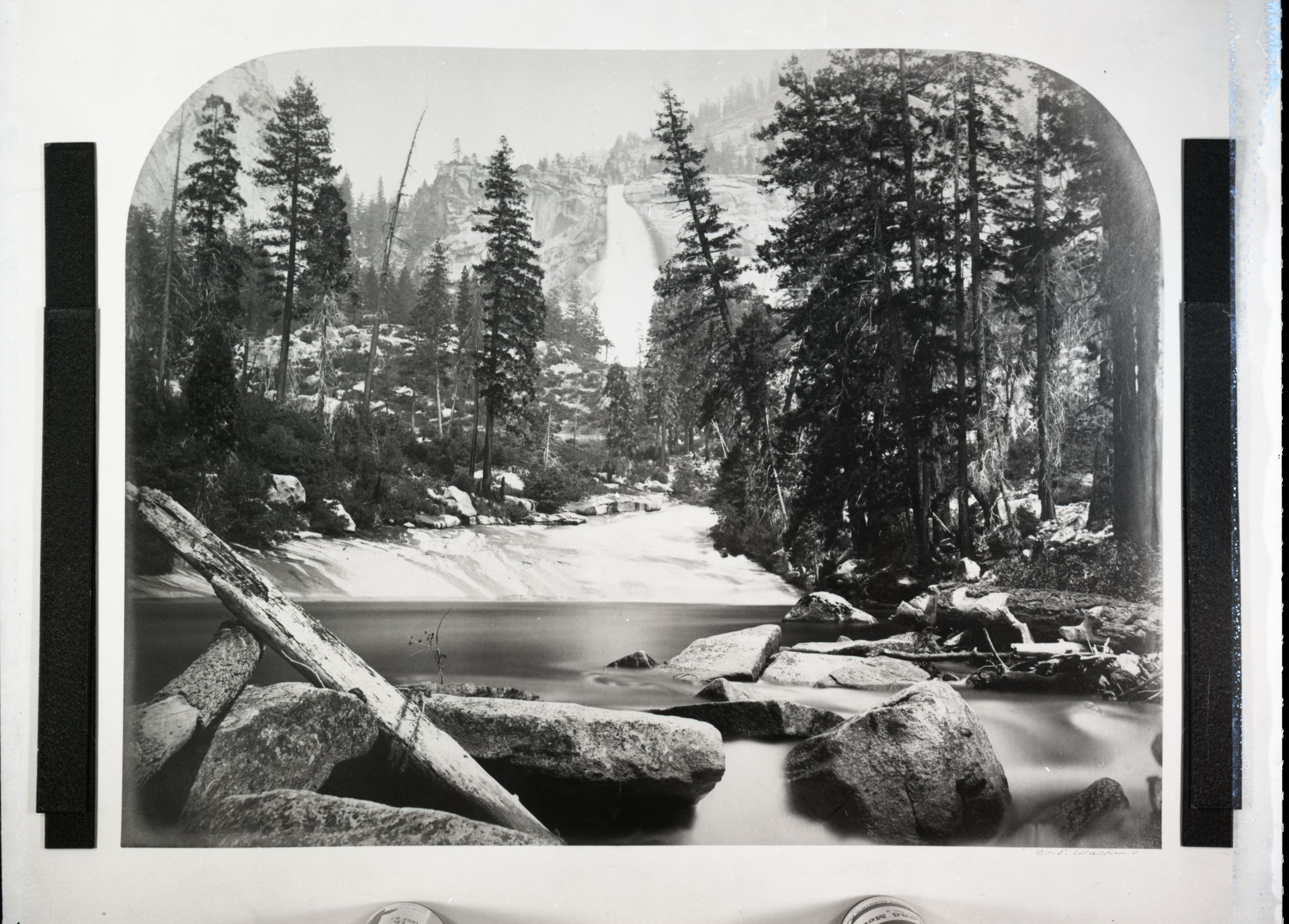
Top: Nevada Fall in 1861, photographed by Carleton E. Watkins (NPS, public domain).
The Mist Trail is Yosemite’s most famous day hike: a steep granite staircase that climbs right beside Vernal Fall and then Nevada Fall, with Liberty Cap and the back of Half Dome rising overhead. But it isn’t the only way to the top of the falls. Here’s how the main routes compare, from a quick out-and-back to Vernal Fall to the long downhill walk from Glacier Point on the Panorama Trail.
Trail status for fall 2026
- Fridays to Sundays and holidays: the full Mist Trail is open.
- Monday to Thursday, 7 a.m. to 3:30 p.m.: the Mist Trail between the John Muir Trail junction (just above the Vernal Fall Footbridge) and the top of Vernal Fall is closed for repairs. Take the John Muir Trail instead. Outside those hours it’s normally open when safe.
- The repair schedule runs through October and may change, so check before you go.
- Good news: the John Muir Trail’s “Ice Cut” section between Clark Point and the Panorama Trail junction reopened in July 2026 after repairs from the 2023 winter storms, bringing back the classic loop.
Routes at a glance
| Route | Distance | Elevation | Time |
|---|---|---|---|
| Vernal Fall Footbridge | 1.6 mi round trip | 400 ft gain | 1–1.5 hr |
| Top of Vernal Fall (Mist Trail) | 2.4 mi round trip | 1,000 ft gain | About 3 hr |
| Top of Nevada Fall (Mist Trail) | 5.4 mi round trip | 2,000 ft gain | 5–6 hr |
| Loop: up the Mist Trail, down the John Muir Trail | About 7 mi | 2,000+ ft gain | Allow 6+ hr |
| John Muir Trail both ways | About 8 mi round trip | 2,000+ ft gain | Allow 6+ hr |
| Panorama Trail, Glacier Point to Happy Isles | 8.5 mi one way | About 3,200 ft net descent | 4–6 hr |
Getting to the trailhead
Every valley route starts at Happy Isles (shuttle stop #16) at the east end of Yosemite Valley. There’s no parking at the trailhead, so park at Curry Village, less than a mile away, and walk or ride the Valleywide or East Valley shuttle. Water and restrooms are at the trailhead. The only water on the trail is at the Vernal Fall Footbridge, and only from May to October.
Option 1: The Mist Trail out and back
A paved path climbs from Happy Isles to the Vernal Fall Footbridge and your first view of the fall. Above the bridge, the Mist Trail heads up a long run of granite steps right beside Vernal Fall to railings at the top, where Emerald Pool and the Silver Apron spread out above the drop. From there, more steps and switchbacks climb to the top of Nevada Fall. Most people come back the same way.
In fall, both waterfalls are at their lowest flow of the year, so the spray that gives the trail its name is mostly gone and the steps are usually drier than in spring. Take the descent slowly either way: the steps are steep, often crowded, and hard on knees.
Weekday tip: Monday to Thursday before 3:30 p.m., use the John Muir Trail to reach the top of Vernal Fall while the Mist Trail repairs continue.
Option 2: The classic loop, up the Mist Trail and down the John Muir Trail
Climb the Mist Trail to the top of Nevada Fall, cross the footbridge over the Merced River near the brink of the fall, and pick up the John Muir Trail for the descent. Its switchbacks are longer but much easier on the knees. Near the top, including the reopened Ice Cut, you get one of the best views of Nevada Fall with Liberty Cap beside it. From the top of Nevada Fall it’s about 4 miles back to Happy Isles on the JMT, passing Clark Point on the way down.
Shorter version: climb to the top of Vernal Fall, continue past Emerald Pool, then take the Clark Point cutoff up to the John Muir Trail and follow it down. The NPS suggests this loop as a way to skip descending the slick, crowded steps beside Vernal Fall.
Option 3: The John Muir Trail both ways
The JMT is the gentler, quieter way up: longer switchbacks, mostly forest on the lower half, and a big view of Nevada Fall near the top. It’s about 4 miles each way to the top of Nevada Fall. At Clark Point you can drop down to the Mist Trail above Vernal Fall, or stay on the JMT all the way to the Nevada Fall footbridge.
Option 4: Start at Glacier Point on the Panorama Trail
For the grandest day, start at the top. The Panorama Trail runs 8.5 miles one way from Glacier Point (about 7,200 feet) down to Happy Isles (about 4,000 feet), with big views of Half Dome along the way. It drops to Illilouette Fall, climbs again to Panorama Point, then descends to the top of Nevada Fall. From there you choose the Mist Trail or the John Muir Trail for the final descent to the valley.
Getting to Glacier Point: there’s no regular shuttle between the valley and Glacier Point. Most hikers buy a one-way ticket on the Glacier Point Tour bus, which generally runs while Glacier Point Road is open, or arrange a second car or a pickup. Glacier Point Road reopened in October 2026 after closures for the Dome Fire, but it typically closes for winter sometime in October or November, so this option is nearly done for the season. Overnight parking isn’t allowed along the road, and some backcountry areas south of the road were still closed after the fire, so check the park’s closure map before you go.
The big loop: very strong hikers sometimes make a full loop from the valley by climbing the Four Mile Trail to Glacier Point first, then coming down the Panorama Trail. It’s a very long, steep day, so check the Four Mile Trail’s current status before you commit.
Know before you go
- Water: carry 3 to 4 liters for Nevada Fall. The Vernal Fall Footbridge is the only refill on the trail, and only from May to October.
- Headlamp: bring one with fresh batteries. Fall days are short, and the hike often takes longer than planned.
- Stay out of the water: swimming or wading at Emerald Pool and the Silver Apron is illegal and dangerous because of strong currents. Stay behind railings at the falls.
- Footing: expect loose rock, decomposed granite and steep, slippery steps. Sprains and knee injuries are common.
- Not allowed: pets, bicycles and strollers.
- Winter closures: once winter sets in, the lower Mist Trail beside Vernal Fall closes because of falling ice and rock, and the John Muir Trail between Clark Point and the top of Nevada Fall closes when icy. A winter route stays open but can be icy or snowy.
Trail information as of October 25, 2026, from the National Park Service. Conditions change quickly, so check the NPS Vernal and Nevada Fall trail page and current conditions before you go.
Leave a Reply